Sea Surface Temp-Anom - Western Hemisphere

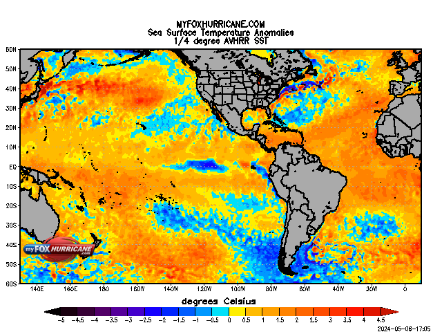
SST Anom. W. Hemisphere Description
Sea surface temperature is one of the factors that contribute to tropical cyclone development. With other factors being equal, warm water can contribute to hurricane intensification. Cool water tends to weaken hurricanes.
The SST anomalies in the image above cover the entire Atlantic and Pacific Oceans. The anomaly shows how much warmer or colder than normal the SST’s are. The SST’s are derived from remote sensing equipment aboard two different satellites and combined to give the best overall estimate. One type of sensor is on the NOAA satellites (AVHRR) and one sensor is on the NASA satellites (AMSR).
NOAA has two polar-orbiting meteorological satellites in orbit at all times, with one satellite crossing the equator in the early morning and early evening and the other crossing the equator in the afternoon and late evening. Together they provide twice-daily global coverage, and ensure that data for any region of the earth are no more than six hours old. The primary sensor on board the NOAA polar-orbiting satellites is the Advanced Very High Resolution Radiometer (AVHRR). Initially, the NOAA/ AVHRR satellites were designed to observe the Earth’s weather in the form of cloud patterns. However, they can also measure sea-surface temperatures.
In a multi-national agreement, NASA has satellites that fly in a different orbit that the polar orbiting NOAA satellites. They are in sun-synchronous orbits. They also fly in tandem. The constellation of satellites flies in the "A train" formation. This allows synergy between the satellites and gives more information than could be obtained from just one satellite individually. One of the sensors on the AQUA satellite is the Advanced Microwave Scanning Radiometer (AMSR). The AMSR measures, among other things, sea-surface temperature.


